Estimation application downloads and cost
Description
farmAR app brings information about soil and crops health directly to the smartphone. All you need is to sign up with an email address and create a farm by drawing a polygon on the map. Your will immediately see the vegetation health map on your smartphone.
The power of farmAR app comes from its fully automated satellite image processing servers. The farm observation from multiple satellites help to calculate the vegetation and soil health in the servers. Via the farmAR app, the users receive updated maps every 4 days.
The users can thus be aware of the health of their field and crops, before even their changing situation is that is visible to the human eye. This leads to quick and efficient decision-making to save crops and to get more yield. On site, farmers can directly decide about the next work steps and save time and money by reducing unnecessary chemical usage.
farmAR app creates positive impact on budget of farmers. As a further positive side effect, plants become healthier and the soil becomes richer.
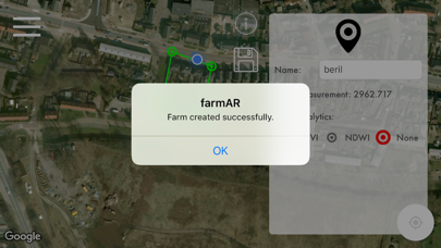
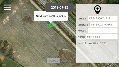
After signing in, the user has to "create a farm" by selecting a polygon region on the map. farmAR app automatically processes the satellite data of the selected area. The vegetation health index shows which areas are growing densely green and which areas are not. The less green areas in the map are the locations which need nutrition or fertilizers. Instead of spraying these chemicals to all farm (which is extremely expensive solution), farmers can treat the areas which need treatment. Reducing amount of chemicals with this precision farming opportunity, reduces the farming costs effectively.
The users now benefit from satellite images very easily, without needing any expert.
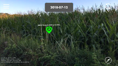
Furthermore, it is possible to create photos and leave those photos as augmented reality (AR) notes in the land. Later, when the users visit their farm again, they can look at their past AR photos and notes and see them at the location where they virtually attached. This gives opportunity to visually compare the past AR photos with the current situation.
The AR photos and notes can also be used for exchanging information between workers of the same farm.
farmAR app is a groundbreaking technology with an advanced satellite data processing and artificial intelligent back-end to support the augmented reality smartphone application.
farmAR is created and owned by create4D.
http://farmar.create4d.com
By signing up, the users are agreeing with our privacy terms and conditions. Our privacy terms and conditions are published at http://privacy.create4d.com
If password recovery is needed, please contact create4D at [email protected] and we send you an email with a link for creating a new password for your existing account.
Read more
The power of farmAR app comes from its fully automated satellite image processing servers. The farm observation from multiple satellites help to calculate the vegetation and soil health in the servers. Via the farmAR app, the users receive updated maps every 4 days.
The users can thus be aware of the health of their field and crops, before even their changing situation is that is visible to the human eye. This leads to quick and efficient decision-making to save crops and to get more yield. On site, farmers can directly decide about the next work steps and save time and money by reducing unnecessary chemical usage.
farmAR app creates positive impact on budget of farmers. As a further positive side effect, plants become healthier and the soil becomes richer.
After signing in, the user has to "create a farm" by selecting a polygon region on the map. farmAR app automatically processes the satellite data of the selected area. The vegetation health index shows which areas are growing densely green and which areas are not. The less green areas in the map are the locations which need nutrition or fertilizers. Instead of spraying these chemicals to all farm (which is extremely expensive solution), farmers can treat the areas which need treatment. Reducing amount of chemicals with this precision farming opportunity, reduces the farming costs effectively.
The users now benefit from satellite images very easily, without needing any expert.
Furthermore, it is possible to create photos and leave those photos as augmented reality (AR) notes in the land. Later, when the users visit their farm again, they can look at their past AR photos and notes and see them at the location where they virtually attached. This gives opportunity to visually compare the past AR photos with the current situation.
The AR photos and notes can also be used for exchanging information between workers of the same farm.
farmAR app is a groundbreaking technology with an advanced satellite data processing and artificial intelligent back-end to support the augmented reality smartphone application.
farmAR is created and owned by create4D.
http://farmar.create4d.com
By signing up, the users are agreeing with our privacy terms and conditions. Our privacy terms and conditions are published at http://privacy.create4d.com
If password recovery is needed, please contact create4D at [email protected] and we send you an email with a link for creating a new password for your existing account.
farmAR App screenshorts

ASO analyse farmAR App app for iPhone and iPad
| # | Term | Store county | Place | Priority |
|---|---|---|---|---|
| 1 | satellite ar | 16 | ⭐️⭐️⭐️⭐️ |
Competitors of farmAR App application
| # | App | Common words |
|---|---|---|
| 1 | Star Walk 2 Ads+:Night Sky Map | 1 |
| 2 | Globe Geography: World Map | 1 |
| 3 | AR Earth | 1 |
| 4 | AR Solar System: AR Planets | 1 |
| 5 | Sat>IP Alignment | 1 |
| 6 | Sputnik 1957 AR | 1 |
| 7 | FingerNavi | 1 |
| 8 | HoloGLOBE | 1 |
| 9 | SpaceStationAR | 1 |
| 10 | 3D Спутник | 1 |
| 11 | SpaceStationAR LITE | 1 |
| 12 | Satellite Pointer | 1 |
| 13 | We Maps 04 | 3D + 2D World Map | 1 |
| 14 | SatFinder Lite | 1 |
| 15 | Star Walk:Find Stars & Planets | 1 |
| 16 | Sky Guide | 1 |
| 17 | Star Walk 2: Stars and Planets | 1 |
| 18 | Satbeams | 1 |
Other apps from Beril Sirmacek
Similar apps