Mud Map 2 | 4WD GPS with Offline maps, Camping & Holiday Park POIs of Australia. at App Store analyse
follow appEstimation application downloads and cost
Description
BONUS OFFER: Buy Mud Map 2 today and receive a free upgrade to the brand new Mud Map 3 app in Nov 2015.
Mud Map 2 is the must have 4WD & Camping GPS app for iPad & iPhone. This is the only app that combines detailed offline 4WD maps with interactive Campsites, inc facilities, photos and reviews.
Simply download Mud Map 2 and your ready to explore OFF the beaten track! Best of all, it works offline, phone or internet reception NOT required. Using the built in GPS in your iPad* or iPhone, your exact location is displayed on a map so you have the confidence to explore anywhere!
*Although a SIM card is not needed, a Cellular model of the iPad is needed for GPS location features. If you have a WiFi only iPad, which does not have a built in GPS, an external GPS receiver can be used.
**FEATURES**
• Highly detailed OFFLINE 4WD maps, works anywhere, no connectivity required. More info below
• See your exact GPS location on any map
• Powerful navigation features
• Maps follow your location as you travel
• Interactive Campsites & Caravan Park info, with facilities, photos & reviews
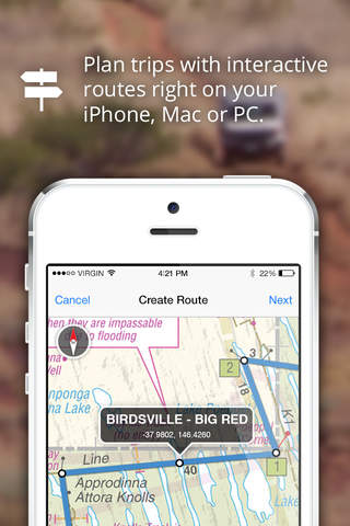
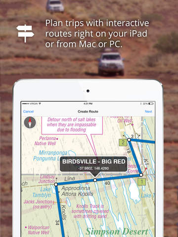
• Plan trips with custom routes on iPad, iPhone, Mac or PC
• Track your progress to see where you have been
• Share your trips right from the app
• Use your existing digital maps from any brand*
*GeoTiff, ECW & most OziExplorer map formats.
**INCLUDED MAPS**
▶ THEMAP - interactive 4WD map of Australia
The first community made, interactive Off-Road map. 4WD enthusiasts, from all over Australia are contributing GPS data, aiming to make this the most detailed & up-to-date Off-Road map for 4WD and touring use.
• Free monthly map updates for life.
• Australia wide coverage.
• Powered by a brand new vector map engine with interactive zoom, which means the level of detail changes depending on the zoom level. Zoom out to see a good overview of Australia, zoom right in to see detailed 4WD track, & points of interest.
• Interactive roads, tracks & POIs. Tap on them to find out more info.
▶ MUD MAP - 4WD touring maps
Highly detailed 4WD touring maps of the most popular 4WD destinations. These maps feature detailed info on 4WD tracks, gates, Campsites, fuel stations, POIs and tourist attractions.
• High Country 50K
• Fraser Island 50K
• Barrington Tops 50K
▶ WESTPRINT - Outback maps
Westprint have put in the hard yards to gather detailed & accurate field data of Australias most popular 4WD destinations. These maps come with all of their personalised notes on:
• Track notes & difficulty ratings
• Relevant permits & passes you may need
• POIs such as caravan sites, camp sites & fuel outlets
• History of the surrounding area
• Interesting attractions
• Road distance markers making it easy to gauge your distance from your destination
Every Westprint 4WD map is included:
• Alice Springs to Oodnadatta
• Alice Springs to Uluru
• Arnhem Land
• Birdsville & Strzelecki Tracks
• Canning Stock Route
• Cape York
• Diamantina Lakes
• Googs Track
• Gulf Country
• Gunbarrel Hwy
• Holl& Track
• Innamincka
• Oodnadatta Track
• Outback Victoria
• Plenty Hwy
• Simpson Desert
• Southwest Queensland
• Tanami Road
• The Kimberley
• Top End
• West Nullarbor
▶ BACK COUNTRY - 4WD Maps
A set of beautifully illustrated maps with seamless coverage of Australia. Tailor made for 4WD & touring enthusiasts BackCountry maps display all of the vital information you need to plan & enjoy your trip. POIs such as campsites & caravan parks are shown so you can easily find the best spot to set up camp for the night.
DISCLAIMER: Continuos use of GPS in the background decreases battery life.
Read more
Mud Map 2 is the must have 4WD & Camping GPS app for iPad & iPhone. This is the only app that combines detailed offline 4WD maps with interactive Campsites, inc facilities, photos and reviews.
Simply download Mud Map 2 and your ready to explore OFF the beaten track! Best of all, it works offline, phone or internet reception NOT required. Using the built in GPS in your iPad* or iPhone, your exact location is displayed on a map so you have the confidence to explore anywhere!
*Although a SIM card is not needed, a Cellular model of the iPad is needed for GPS location features. If you have a WiFi only iPad, which does not have a built in GPS, an external GPS receiver can be used.
**FEATURES**
• Highly detailed OFFLINE 4WD maps, works anywhere, no connectivity required. More info below
• See your exact GPS location on any map
• Powerful navigation features
• Maps follow your location as you travel
• Interactive Campsites & Caravan Park info, with facilities, photos & reviews
• Plan trips with custom routes on iPad, iPhone, Mac or PC
• Track your progress to see where you have been
• Share your trips right from the app
• Use your existing digital maps from any brand*
*GeoTiff, ECW & most OziExplorer map formats.
**INCLUDED MAPS**
▶ THEMAP - interactive 4WD map of Australia
The first community made, interactive Off-Road map. 4WD enthusiasts, from all over Australia are contributing GPS data, aiming to make this the most detailed & up-to-date Off-Road map for 4WD and touring use.
• Free monthly map updates for life.
• Australia wide coverage.
• Powered by a brand new vector map engine with interactive zoom, which means the level of detail changes depending on the zoom level. Zoom out to see a good overview of Australia, zoom right in to see detailed 4WD track, & points of interest.
• Interactive roads, tracks & POIs. Tap on them to find out more info.
▶ MUD MAP - 4WD touring maps
Highly detailed 4WD touring maps of the most popular 4WD destinations. These maps feature detailed info on 4WD tracks, gates, Campsites, fuel stations, POIs and tourist attractions.
• High Country 50K
• Fraser Island 50K
• Barrington Tops 50K
▶ WESTPRINT - Outback maps
Westprint have put in the hard yards to gather detailed & accurate field data of Australias most popular 4WD destinations. These maps come with all of their personalised notes on:
• Track notes & difficulty ratings
• Relevant permits & passes you may need
• POIs such as caravan sites, camp sites & fuel outlets
• History of the surrounding area
• Interesting attractions
• Road distance markers making it easy to gauge your distance from your destination
Every Westprint 4WD map is included:
• Alice Springs to Oodnadatta
• Alice Springs to Uluru
• Arnhem Land
• Birdsville & Strzelecki Tracks
• Canning Stock Route
• Cape York
• Diamantina Lakes
• Googs Track
• Gulf Country
• Gunbarrel Hwy
• Holl& Track
• Innamincka
• Oodnadatta Track
• Outback Victoria
• Plenty Hwy
• Simpson Desert
• Southwest Queensland
• Tanami Road
• The Kimberley
• Top End
• West Nullarbor
▶ BACK COUNTRY - 4WD Maps
A set of beautifully illustrated maps with seamless coverage of Australia. Tailor made for 4WD & touring enthusiasts BackCountry maps display all of the vital information you need to plan & enjoy your trip. POIs such as campsites & caravan parks are shown so you can easily find the best spot to set up camp for the night.
DISCLAIMER: Continuos use of GPS in the background decreases battery life.
Mud Map 2 | 4WD GPS with Offline maps, Camping & Holiday Park POIs of Australia. screenshorts


ASO analyse Mud Map 2 | 4WD GPS with Offline maps, Camping & Holiday Park POIs of Australia. app for iPhone and iPad
No search terms founded
Competitors of Mud Map 2 | 4WD GPS with Offline maps, Camping & Holiday Park POIs of Australia. application
Other apps from Equibs Solutions Pty Ltd


Similar apps